
Altus M7
Premium AR Measurement with Dual-Sized Cameras
The M8 features dual-sized cameras (front telephoto/wide-angle & bottom wide-angle) for professional AR measurement, delivering sub-centimeter accuracy. Built with high-cost industrial-grade components and customized AR chips, it outperforms single-camera solutions, supporting long-distance telephoto measurement and wide-angle scene scanning for construction, surveying and industrial inspection.
Overview
Benefits and Performances
-
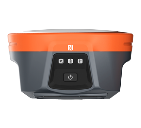
01 Professional GNSS
Ensure robust data quality with the i73+'s advanced 1408-channel GNSS technology, which efficiently tracks satellite signals from all constellations, including GPS, GLONASS, Galileo, BeiDou, QZSS and SBAS.Ensure robust data quality with the i73+'s advanced 1408-channel GNSS technology, which efficiently tracks satellite signals from all constellations, including GPS, GLONASS, Galileo, BeiDou, QZSS and SBAS. -
02 Built-In Modems
Compatible with all major radio protocols, the i73+ operates as both a base and rover, delivering high productivity. When connected to a GNSS RTK network via LandStar field software, it excels as a highly efficient NTRIP rover.Compatible with all major radio protocols, the i73+ operates as both a base and rover, delivering high productivity. When connected to a GNSS RTK network via CHCNAV LandStar field software, it excels as a highly efficient NTRIP rover. -
03 Portable and Lightweight
Weighing just 0.73 kg, the i73+'s compact magnesium alloy design ensures easy portability and operation, reducing operator fatigue and enhancing survey comfort during fieldwork.Weighing just 0.73 kg, the i73+'s compact magnesium alloy design ensures easy portability and operation, reducing operator fatigue and enhancing survey comfort during fieldwork. -
04 Pole Tilt Compensation
Boost point measurement efficiency by 20% and stakeout speed by 30% with the i73+. Its automatic compensation for up to 60° pole tilt removes the need for precise pole leveling, enhancing field productivity.Boost point measurement efficiency by 20% and stakeout speed by 30% with the i73+. Its automatic compensation for up to 60° pole tilt removes the need for precise pole leveling, enhancing field productivity. -
05 Rugged and Durable
With an IP67 rating, the i73+ is fully dustproof and waterproof, delivering reliable performance in harsh environments. Its rugged design resists shock and vibration, making it ideal for demanding fieldwork.With an IP67 rating, the i73+ is fully dustproof and waterproof, delivering reliable performance in harsh environments. Its rugged design resists shock and vibration, making it ideal for demanding fieldwork. -
06 Extended Battery Life
Perform extensive surveys with the i73+'s 6800 mAh battery, offering up to 24 hours of RTK rover operation and 10.5 hours of UHF RTK base operation, ensuring reliable performance throughout long field sessions.Perform extensive surveys with the i73+'s 6800 mAh battery, offering up to 24 hours of RTK rover operation and 10.5 hours of UHF RTK base operation, ensuring reliable performance throughout long field sessions.
Professional GNSS - 1408-channel GNSS technology
Built-In Modems - Compatible with all major radio protocols
Portable and Lightweight - Only 0.73 kg
Pole Tilt Compensation - Up to 60° automatic compensation
Rugged and Durable - IP67 dustproof and waterproof
Extended Battery Life - Up to 24 hours of operation
Specifications
Specifications
Specifications
Resources
CHCNAV ViLi i100
Visual-LiDAR GNSS RTK receiver with consistent accuracy in obstructions
Positioning
- GNSS : Full GNSS
- IMU : 200 Hz
- Precision max. : 0.8 cm H / 1.5 cm V
Physical
- Weight : 1.39 kg
- Screen size : 208 x 162 x 95.5 mm
Connectivity
- Wireless : Bluetooth, Wi-Fi
- Cellular : No
- Modem : 410 - 470 MHz, Rx only
- Ports : 1 x USB V3.0 Type-C port, 1 x UHF antenna port
LiDAR
- Range : 30 m @ 10% reflectivity 70 m @ 80% reflectivity
- FOV : H: 360° V: 90°
- Eye - Safety Class : Class 1 (EC60825 - 1:2014) eye - safe
- Point Frequency : 860,544 pts/s (single - echo mode)
- Accuracy (Typical) : 1.5 cm (1 σ)
Download
ViLi_i100_DS_EN.pdf
2.62 MB