.png)

Slam
R7 SLAM System
The R7 SLAM system achieves high-precision positioning: ±1cm (static indoor environment), ±3cm (dynamic indoor environment), and ±5cm (outdoor semi-occluded environment). It adopts multi-sensor fusion (LiDAR + IMU + visual camera) to ensure stable accuracy even in environments with missing features or frequent light changes.
The R7 supports mainstream map formats including PCD (Point Cloud Data), PNG/JPG (2D occupancy grid map), GeoTIFF (georeferenced map), and ROS bag (raw data package). It also supports custom format export via SDK, compatible with third-party robotics platforms (ROS1/ROS2) and mapping software (CloudCompare, MeshLab).
The R7 is widely used in industrial AGV navigation, warehouse robot positioning, indoor construction surveying, underground pipeline mapping, and unmanned vehicle navigation in complex environments. It adapts to narrow corridors, high-dynamic industrial sites, and outdoor unstructured environments (e.g., construction sites, orchards).
The R7 achieves fast initialization (≤3 seconds) after power-on, and the real-time mapping speed reaches 5m/s (maximum movement speed of the carrier). For a 1000㎡ indoor space, it can complete high-precision mapping within 15 minutes, and the map can be optimized in real time during movement without post-processing.
The R7 is equipped with multi-dimensional anti-interference technology: 1) LiDAR anti-glare algorithm (resistant to strong light/backlight interference); 2) IMU drift correction (supports 30s pure inertial navigation when LiDAR is blocked); 3) visual feature enhancement (adapts to low-light/feature-poor environments); 4) electromagnetic interference shielding (compatible with industrial electromagnetic environments).
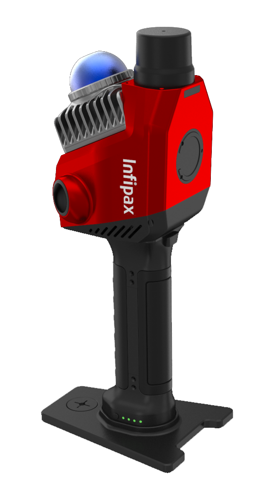
The R7 integrates a 128-line mechanical LiDAR (detection range 0.1-200m, angular resolution 0.1°×0.2°), a 6-axis high-precision IMU (drift ≤0.01°/h), a 4K RGB-D camera (frame rate 30fps), and an industrial-grade computing core (NVIDIA Jetson Orin NX). It has IP65 protection and supports 12-24V wide voltage power supply.
The R7 supports dual-band Wi-Fi (802.11ax), Ethernet (1000Mbps), and 4G/5G wireless data transmission, with real-time data upload latency ≤20ms. It has 256GB built-in SSD storage (expandable to 2TB via SSD slot) for storing raw point cloud data and map files, and supports automatic cloud synchronization via MQTT protocol.
On-site calibration steps: 1) Place the R7 on a calibration plate with known coordinates; 2) Run the built-in calibration tool (R7 Calibration Tool) via the touch screen; 3) Complete LiDAR-IMU-camera extrinsic parameter calibration (≤5 minutes); 4) Verify with 3-5 check points (error ≤2cm is qualified). Remote calibration is also supported via cloud platform.
The R7 is equipped with a built-in 24V/10000mAh lithium battery, providing 8 hours of continuous operation in portable mode (LiDAR + computing core full load) and 12 hours in low-power mode. It supports fast charging (0-100% in 2 hours) and hot-swappable battery design to avoid operation interruption.
Yes. The R7 provides a full set of SDK (support C/C++, Python, ROS1/ROS2) with detailed development documents and sample code. It includes APIs for real-time positioning, map editing, sensor data acquisition, and path planning, supporting custom integration with AGV, UAV, and robotic arm control systems. Technical support and development training are also provided.